MONDAY, SEPTEMBER 24, 2012
Cathi and I took a day off to have a grand adventure! We'd been wanting to go to the Olympic Peninsula to see where the dams had been removed from the
Elwha River, so we finally made it happen. Up before dawn to catch the ferry - while we waited for it, the view across the lake toward the road, with mist hugging the ground as a car approaches.
Next we watched an amazing sunrise from the ferry, thanks in part to the fires east of the mountains!
The site of the Elwha Dam, now completely removed and being replanted. The bare hillside was the location of the powerhouse, and the dam itself was on the left, between the rocky canyon walls. Upstream, you can see where some vegetation is already greening up the lake bed.
We drove up to the other end of the long narrow lake, where you can get out and walk around on it via the old boat ramp. We met a group of scientists with a UAV - unmanned aerial vehicle - flying it over the lake bed to take photos and gather data.
Here is more info. It is a joint effort with the USGS, BLM, and Nat. Park Service. The plane is a
Raven RQ 11A. The guys were very nice and explained a lot to us!
Then we went on to walk about 1/2 mile down the lake bed as far as we could. The valley had been logged before the dam was built 100 years ago, and the stumps survived under the water. Because of the amount of the sediment: sand, mud and gravel, we have decided there are likely just as many stumps under our feet, too!
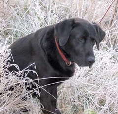
Cathi and Tui playing around one of the huge cedar stumps, showing the spring-board notches used to cut it down.
Some really good news is that the salmon are already coming in to spawn - we saw a couple of old spawners on the beach. You can see how the nose really hooks around!
A panoramic view from the end, looking back to the south and the Olympic Mountains. We couldn't go any further on this side of the river because of steep cliffs.
This panorama is from much further south, looking back to the north to the area we stopped at.
Then we drove up the river valley to the next dam, the Glines Canyon dam. It is still in the process of removal, which involves dynamite! Unfortunately, they weren't blasting while we were here! But we could drive to the far end of the lake and hike down to it. Since it is much more recent than the first lake, there isn't any vegetation at all, just lots of rocks and mud. This is looking toward the south where the river ran into the lake.
Since they had the dam area restricted, we had to settle for peek-a-boo views through the trees. But you can just make out the breached dam, with a huge crane sitting on the left side. It was originally over 200 feet tall! They are taking this one out in stages, so as not to overwhelm the lower part of the river with sediment and water all at once.
There is a wonderful little waterfall, Madison Falls, just a very short hike from the road.
Finally, we drove out to the Straits of San de Fuca to see the river mouth. Above is the view across the estuary, and you can barely see the straits over the vegetation. Below, from the other side of the river, looking back at the estuary. It was sunset, and we couldn't really see any of the sediment fanning out into the straits, but they told us it is building up the beaches here.
All in all, an amazing day!


No comments:
Post a Comment